
About Mount Rinjani Trekking : Are you a nature lover and mountain connoisseur? It’s not complete if you haven’t felt the sensation of climbing on a mountain that is famous for its beautiful natural charm. With an altitude of 3,726 meters above sea level and located in the north of Lombok Island, Mount Rinjani is the second highest volcano in Indonesia.
Entering the Mount Rinjani National Park area and surrounded by forests and shrubs covering an area of 76,000 hectares, it is a beautiful sight for Mount Rinjani.
Access to Lombok Island, besides being able to be reached by land using a direct bus from Jakarta to Mataram by crossing using a ferry twice (BaliStrait and Lombok Strait), can also be reached by airplane from various countries around the world, such as France, Germany, Italy. , Spain, Norway, Canada, USA, Belgium, England, Netherlands, or Asian countries such as Malaysia, Singapore, Thailand, India, Vietnam, China, and so on. Even from Australia, of course, as one of the largest visitor countries to Lombok Island, especially for outdoor activities Trekking and Hiking Rinjani.
Mount Rinjani has a crater with a width of about 10 km and there is a crater lake called Lake Segara Anak with a depth of about 230 m. With the color of the water turning blue like a child of the ocean, the water flowing from this lake forms a very beautiful waterfall and flows through a steep ravine. Many climbers fish in this lake because there are many goldfish and tilapia.
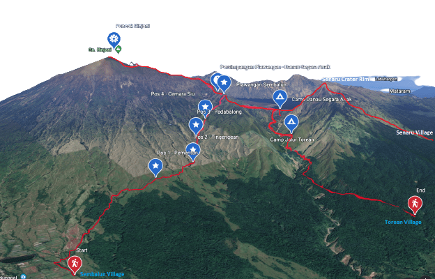
Sembalun Trekking Route
Sembalun Trekking Route is a popular hiking trail in Lombok, Indonesia. It is one of the two main routes to climb Mount Rinjani, the second highest volcano in Indonesia. The route starts from the village of Sembalun Lawang, which is located on the eastern side of the volcano.
The Sembalun Trekking Route is known for its scenic beauty and is a favorite among hikers. The trek starts at an altitude of around 1,150 meters and gradually climbs up to the Sembalun crater rim, which stands at 2,639 meters. Along the way, hikers can enjoy stunning views of the surrounding landscape, including green hills, rice terraces, and the crater lake. The trek usually takes around two to three days to complete, depending on the pace of the hiker.
- The first day involves a long and steep climb up to the Sembalun crater rim. Hikers usually spend the night at one of the campsites near the rim, where they can enjoy spectacular views of the sunset and sunrise over the volcano.
- The second day involves a descent down to the crater lake, which is known as Segara Anak. Hikers can take a refreshing dip in the lake before continuing on to the hot springs, located near the lake. The third day involves a climb up to the Rinjani summit, which stands at 3,726 meters. This part of the trek is considered to be the most challenging, as it involves a steep and strenuous climb.
Overall, the Sembalun Trekking Route is a challenging yet rewarding hiking experience that offers stunning views of one of Indonesia’s most iconic volcanoes. It is recommended for experienced hikers who are physically fit and well-prepared for the climb.
Senaru Trekking Route
The Senaru Trekking Route is the other popular hiking trail to climb Mount Rinjani, the second highest volcano in Indonesia. It starts from the village of Senaru, which is located on the northern side of the volcano.
The Senaru Trekking Route is shorter than the Sembalun Trekking Route and usually takes two days to complete. The trek starts at an altitude of around 600 meters and climbs up to the Senaru crater rim, which stands at 2,641 meters. Along the way, hikers can enjoy stunning views of the surrounding landscape, including lush forests, waterfalls, and the crater lake.
- On the first day, hikers climb up to the Senaru crater rim and spend the night at one of the campsites near the rim. From here, they can enjoy panoramic views of the surrounding landscape and the sunset over the volcano.
- On the second day, hikers can choose to descend down to the crater lake, which is known as Segara Anak, and the hot springs located nearby. Alternatively, they can climb up to the Rinjani summit, which stands at 3,726 meters. This part of the trek is challenging and requires a good level of fitness and endurance.
Note : The Senaru Trekking Route is suitable for both experienced and inexperienced hikers, as it is shorter and less strenuous than the Sembalun Trekking Route. However, it still requires a good level of physical fitness and preparation, including proper hiking gear, food, and water.
Overall, the Senaru Trekking Route is a beautiful hiking experience that offers stunning views of Mount Rinjani and its surrounding landscape. It is a popular choice among tourists visiting Lombok, Indonesia.